Objectives This study aimed to analyze the epidemiology and trends of hemorrhagic fever with renal syndrome (HFRS) in Weifang, China (2013–2021) and to guide prevention strategies.
Methods The study examined the prevalence and incidence trends of HFRS in Weifang (2013–2021). Spearman correlation and wavelet analysis were employed to explore variable relationships and their associations with HFRS incidence. Generalized additive models (GAMs) were used to identify key risk factors, while structural equation modeling (SEM) quantified direct and indirect pathways influencing HFRS transmission. Finally, Bayesian time-series models were applied to predict future HFRS risk.
Results Weifang reported 2,118 HFRS cases, which displayed distinct seasonality. Spearman correlation linked economic factors (gross domestic product [GDP], crop area, grain output, green space) and meteorological factors (temperature, pressure) to incidence (r>0.8). Wavelet analysis identified Mus musculus (2013–2016) and Rattus norvegicus (2017–2021) as dominant reservoirs, with temperature, precipitation, and humidity correlating with incidence. GAMs revealed a U-shaped relationship between rodent density and HFRS and an inverted U-shaped relationship between temperature (threshold, 11.64 °C) and HFRS. SEM highlighted the direct and indirect effects of climate via rodent density, mirrored by economic factors (e.g., GDP). Bayesian models effectively predicted HFRS (root mean square error, 7.36; mean absolute percentage error, 0.28; R2=0.65).
Conclusion Climate, economic, and anthropogenic factors drive the spread of HFRS. Prevention strategies should integrate local economic conditions with meteorological and anthropogenic factors. Bayesian time-series modeling effectively predicts HFRS trends, supporting precision prevention strategies.
Citations
Citations to this article as recorded by
Epidemiological characteristics and spatiotemporal heterogeneity of hemorrhagic fever with renal syndrome in the Jiaodong Peninsula region, China, 2019–2025 Xiaofang Guo, Ti Liu, Ruixiao Li, Xueying Tian, Yuwei Zhang, Xiaotong Shi, Qing Duan, Renpeng Li, Zengqiang Kou Frontiers in Public Health.2026;[Epub] CrossRef
Drivers of Viral Spillover: An Examination of How Pathogens Spread Elenoire Sole, Giulia Montalbano, Giuseppe Motta, Maria Maddalena Pansera, Angelina Midiri, Mariarita Iacopino, Paolo Liotta, Giuseppe Mancuso, Carmelo Biondo Pathogens.2026; 15(9): 901. CrossRef
Objectives Scrub typhus, caused by Orientia tsutsugamushi, is a climate-sensitive vector-borne disease with high incidence in the Republic of Korea. This study examined long-term epidemiological trends and changing meteorological influences in the context of climate change.
Methods A retrospective time-series study was conducted using national surveillance data on 149,289 scrub typhus cases (2001–2024) across 4 surveillance phases. Temporal trends in age-standardized incidence rates were evaluated using Joinpoint regression. Associations between monthly meteorological variables and incidence were assessed with Spearman correlation analysis and time-series regression analysis using distributed lag non-linear models.
Results The national incidence increased until 2017 and has decreased since 2018, whereas the AAPC rebound to 4.32% during phase IV (2019–2024). The proportion of female cases decreased, while that of adults ≥70 years increased significantly. In phase IV, the average annual percent change increased in central and urban regions. The lag effect of meteorological factors lengthened from 4 to 6 months, with mean temperature (Tmean) and relative humidity (RH) representing the primary predictors. Phase III (2013–2018) displayed the highest cumulative relative risk (RR) for Tmean at 25.2 °C (RR, 5.86; 95% confidence interval [CI], 2.56–13.42), whereas in phase IV, only moderate RH (58%) remained significantly associated with incidence (RR, 1.68; 95% CI, 1.29–2.20).
Conclusion Over the past 2 decades, the influence of meteorological factors on scrub typhus has shifted, with recent years marked by greater uncertainty under increasing climate variability and instability. For timely risk prediction and targeted prevention, adaptive surveillance systems that integrate dynamic climate indicators—capturing the intensity, frequency, and variability of extreme weather events—are needed.
Citations
Citations to this article as recorded by
A Review of Domestic Research and Response Trends Regarding the Environmental and Health Impacts of Climate Change Young Sun Kwon, Junsuk Kang Journal of Environmental Health Sciences.2026; 52(1): 7. CrossRef
Non-linear effects and lag patterns of eco-environmental factors on scrub typhus: a spatiotemporal analysis in Yunnan, China, 2015–2022 Xiangnan Jing, Yuewei Ling, Ruonan Jing, Fuying Guo, Feifei Yin, Dongsheng Huang, Lijie Zhang, Xiangyu Yan, Tiejun Shui Parasites & Vectors.2026;[Epub] CrossRef
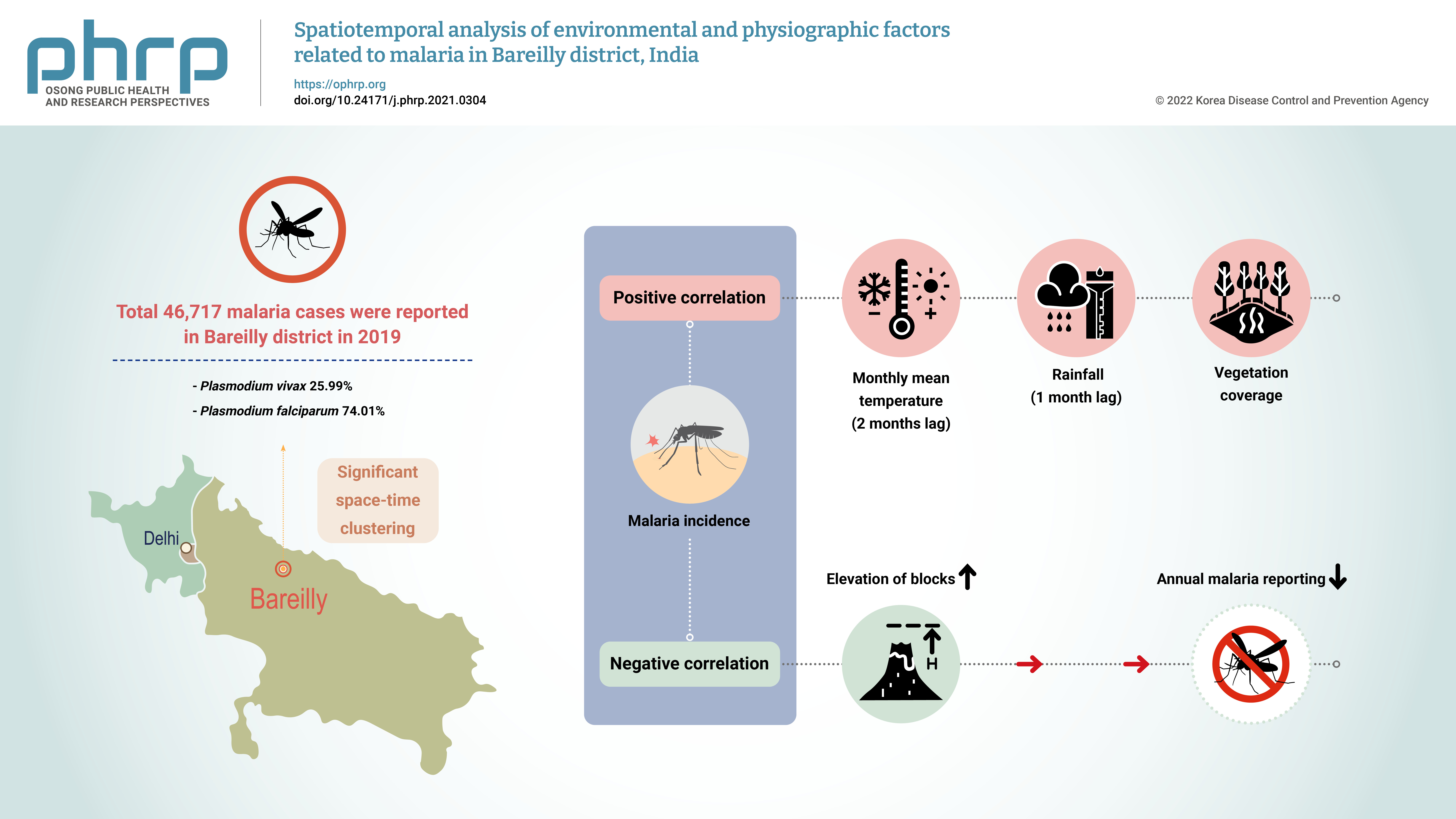
Objectives The aim of this study was to explore the spatiotemporal clustering of reported malaria cases and to study the effects of various environmental and physiographic factors on malaria incidence in Bareilly district, Uttar Pradesh, India. Methods: Malaria surveillance data were collected from the state health department and cleaned into an analyzable format. These data were analyzed along with meteorological, physiographic, and 2019 population data, which were obtained from the Indian Meteorological Department, National Aeronautics and Space Administration web portal, the Bhuvan platform of the Indian Space Research Organization, and the 2011 Census of India. Results: In total, 46,717 malaria cases were reported in Bareilly district in 2019, of which 25.99% were Plasmodium vivax cases and 74.01% were P. falciparum cases. The reported malaria cases in the district showed clustering, with significant spatial autocorrelation (Moran’s I value=0.63), and space-time clustering (p<0.01). A significant positive correlation was found between monthly malaria incidence and the monthly mean temperature (with a lag of 1−2 months) and rainfall (with a lag of 1 month). A significant negative correlation was detected between the elevation of blocks (i.e., intermediate-level administrative districts) and annual malaria reporting. Conclusion: The presence of space-time clustering of malaria cases and its correlation with meteorological and physiographic factors indicate that routine spatial analysis of the surveillance data could help control and manage malaria outbreaks in the district.
Citations
Citations to this article as recorded by
Revisiting the impacts of geographical aspects on public health in the tropical-Asian countries: a review Arif Ashari, Muhamad Ervin, Grace Helena Amaranthois Kapisan, Muhammad Asrori Indra Wardoyo, Raisya Arzety Olivia, Bagus Tegar Sakti Prakosa Reviews on Environmental Health.2026; 41(2): 307. CrossRef
Spatial Analysis of Malaria in Bangladesh: Insights from Bayesian Disease Mapping Models Ummehani Mimi, Md. Rezaul Karim, Sultana Begum, Khadiza Akter Eme, Denekew Bitew Belay PLOS One.2026; 21(8): e0353483. CrossRef
Association between temperature and malaria (1959-2019): a systematic review and meta-analysis Yogesh Murugan, Vaibhavkumar Shrivastav Archives of Public Health.2025;[Epub] CrossRef
Digital health: trends, opportunities and challenges in medical devices, pharma and bio-technology Naresh Kasoju, N. S. Remya, Renjith Sasi, S. Sujesh, Biju Soman, C. Kesavadas, C. V. Muraleedharan, P. R. Harikrishna Varma, Sanjay Behari CSI Transactions on ICT.2023; 11(1): 11. CrossRef



 First
 Prev


